


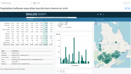
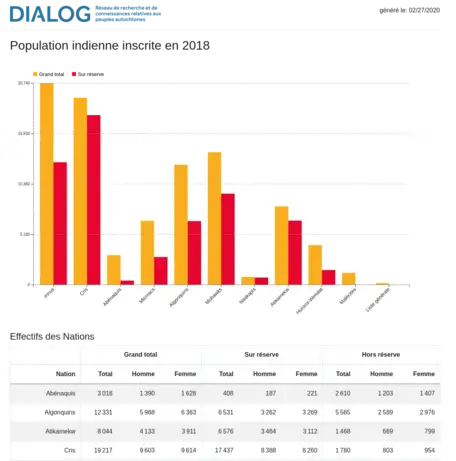
The Atlas of the First Nations of Québec population registered in the Indian Register is a georeferenced and interactive database. It brings together statistical data concerning the Aboriginal population registered in Quebec from 1998 to 2024, depending on whether they live on reserve or off reserve; these data come from Indigenous Services Canada (SAC) which publishes annually on its website a document entitled Registered Indian Population by Sex and Type of Residence.
The department is required by the Indian Act to record in the Indian Register the names of individuals in accordance with the law. The data contained in this atlas correspond to the Registered Indian population as recorded on December 31 of each year. However, the Indian Register « does not include all persons who are entitled to be registered according to the Indian Act, only those who have applied to be registered and whose entitlement has been verified. » (AANDC 2014). Consequently, the data on the registered Indian population does not constitute an exact count of each First Nation.
The Atlas offers series of maps and histograms presenting annual compilations for the whole of Québec on the one hand, and for each of the First Nation on the other. The maps are built from different technologies that allow the development of interactive cartography features on the Internet.
By collecting this data, DIALOG Network aims to make information essential to understanding Indigenous realities in Québec accessible by various electronic and educational means.
Technologies: OpenLayer, D3, Scalable Vector Graphics (SVG), JSON
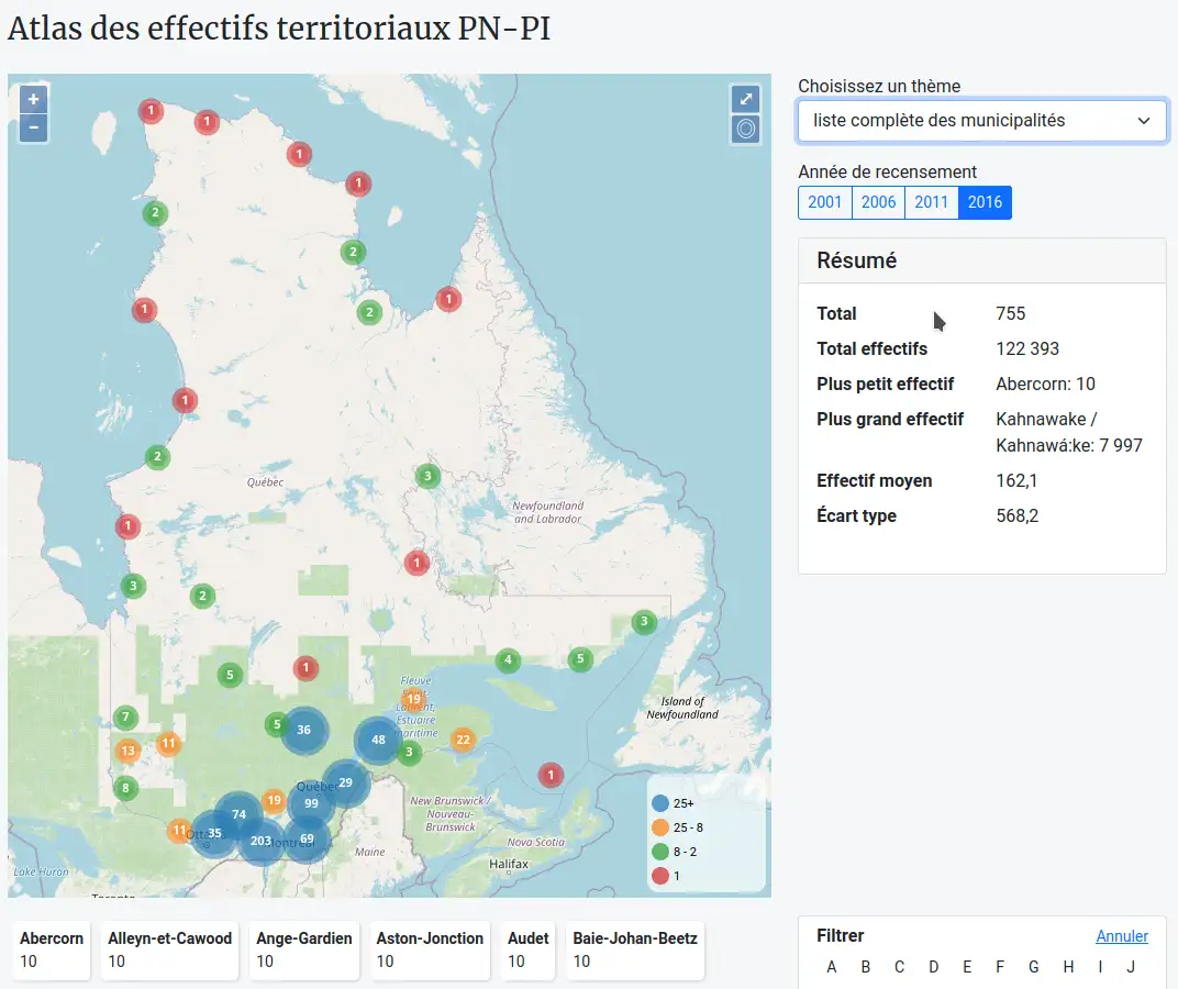
This Atlas constitutes a georeferenced and interactive database. It presents Statistics Canada data relative to the population of First Nations and Inuit Peoples residing in municipalities of the province. Statistics Canada provides data on persons declaring an Indigenous identity. The data presented in this Atlas correspond solely to the population of First Nations and Inuit Peoples. These data stem from quinquennial censuses carried out in all census subdivisions (CSB) of Canada (that is, municipalities/cities and Indigenous territories/communities) between 2001 and 2021. These data are distributed according to age and gender. This means that the Métis population, as identified by Statistics Canada for the Province of Québec and generally included in the category "Indigenous identity", is excluded from the data compilations.
This Atlas offers series of maps and histograms presented compilations for all municipalities in Québec based on censuses of 2001, 2006, 2011, 2016 and 2021. It also reports for the year 2021: 1) information on 49 municipalities with a total population includes at least 5% of First Nations and Inuit People; 2) information on 30 municipalities with a total population includes at least 300 persons of First Nations and Inuit People; 3) Indigenous population residing in municipalities where native friendship centres are established. The maps are built from different technologies that allow the development of interactive cartography features on the Internet.
By collecting this data, DIALOG Network aims to make information essential to understanding Indigenous realities in Québec accessible by various electronic and educational means.
Technologies: OpenLayer, D3, Scalable Vector Graphics (SVG)
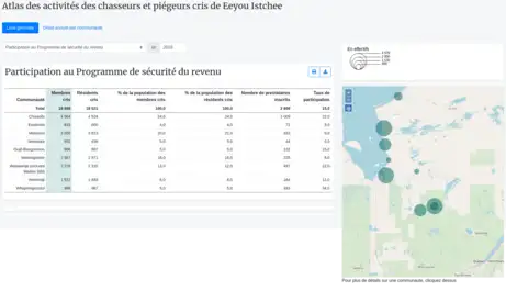
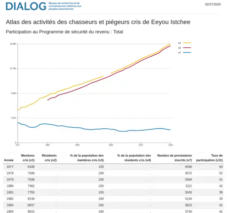
The Atlas of activities of the Cree Hunters and Trappers of Eeyou Istchee (James Bay region) is a georeferenced and interactive database. It presents the annual statistical data of the Cree Hunters and Trappers Income Security Board (CHTISB), a government body that manages the Cree Hunters and Trappers Income Security Program. The data reproduced in this Atlas concern the ten Cree communities of Eeyou Istchee for the years 1977 to 2024. The Atlas aims to facilitate access to the public data of the CHTISB using an innovative tool based on Internet technologies, which is user-friendly, efficient and bilingual. In order to facilitate their consultation, the data have been grouped by major themes: Cree Population, Participation on the Program, Total days paid, Total benefits paid, etc.
The Atlas offers series of maps and histograms presenting annual compilations for the whole of Eeyou Istchee on the one hand, and for each of the Cree communities on the other hand. The maps are built from different technologies that allow the development of interactive cartography features on the Internet.
By collecting this data, the DIALOG Network aims to make information essential to understanding Indigenous realities in Quebec accessible by various electronic and educational means
Technologies: OpenLayer, D3, Scalable Vector Graphics (SVG)
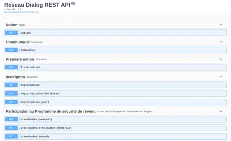
This service allows you to obtain all the data that the DIALOG Network makes available for your personal research needs. All the data feeding our atlases can be downloaded via this platform. If you have specific needs, please do not hesitate to contact us.
Technologies: REST, JSON, CSV